What Are the Future Prospects for Using Satellite Data for Land Cover Mapping?
Land cover mapping is a crucial aspect of environmental monitoring and planning, providing valuable insights into the distribution and changes in Earth's land surface. Satellite data has revolutionized land cover mapping, offering significant advantages over traditional methods. This article explores the current state and future prospects of using satellite data for land cover mapping, highlighting advancements in technology, data processing techniques, and applications.
Current State Of Satellite Data For Land Cover Mapping
Types Of Satellite Data
- Optical data: Provides visible and near-infrared bands, capturing detailed information about land surface features.
- Radar data: Utilizes microwave wavelengths, enabling mapping in all weather conditions and through cloud cover.
- Hyperspectral data: Offers hundreds of narrow spectral bands, allowing for discrimination of subtle spectral differences.
Spatial, Spectral, And Temporal Resolutions
Satellite data varies in its spatial, spectral, and temporal resolutions, impacting the level of detail and frequency of land cover mapping.
- Spatial resolution: Determines the size of the smallest object that can be detected, ranging from meters to kilometers.
- Spectral resolution: Refers to the number and width of spectral bands, influencing the ability to distinguish different land cover types.
- Temporal resolution: Indicates the frequency at which satellite data is acquired, affecting the ability to monitor land cover changes.
Successful Land Cover Mapping Projects
Numerous successful land cover mapping projects have demonstrated the effectiveness of satellite data. Examples include:
- Global Land Cover Characterization (GLCC): Provides global land cover maps at 300-meter resolution using multi-source satellite data.
- European Space Agency's (ESA) Land Cover Climate Change Initiative (LC-CCI): Produces consistent land cover maps for Europe and Africa using multiple satellite missions.
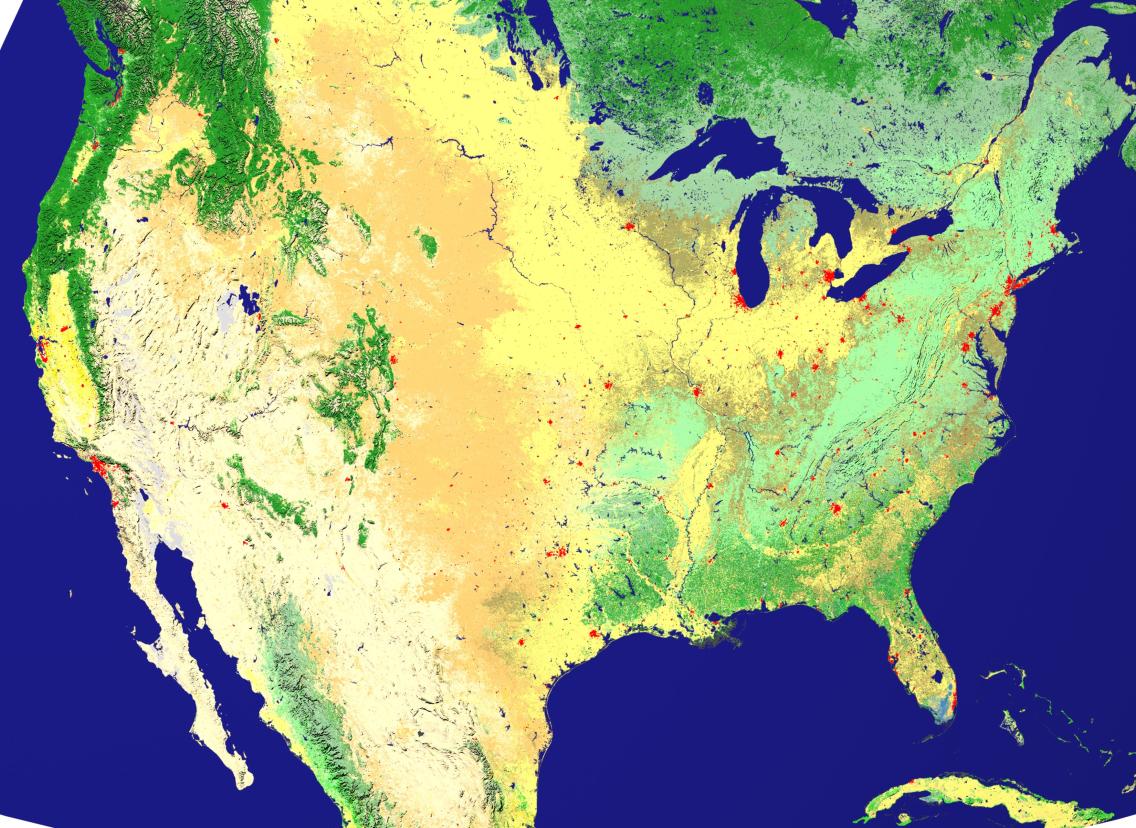
- National Land Cover Database (NLCD) in the United States: Generates land cover maps for the entire country using Landsat satellite data.
Future Prospects For Satellite Data In Land Cover Mapping
Advancements In Satellite Technology
- Improved spatial, spectral, and temporal resolutions: Future satellite missions aim to provide higher-resolution data, enabling more detailed land cover mapping.
- Development of new sensors and platforms: Emerging technologies, such as hyperspectral and radar sensors, offer enhanced capabilities for land cover mapping.
- Increased availability of open-source satellite data: Initiatives like the Copernicus program provide free and open access to satellite data, facilitating broader use in land cover mapping.
Emerging Data Processing Techniques
- Machine learning and artificial intelligence algorithms: These techniques enable automated feature extraction and classification, improving the accuracy and efficiency of land cover mapping.
- Cloud computing and distributed processing: Cloud platforms offer scalable computing resources, enabling the processing of large satellite datasets.
- Integration of multi-source data: Combining satellite data with other data sources, such as aerial imagery and ground-based observations, enhances the accuracy and completeness of land cover maps.
Challenges And Opportunities
Data Volume And Processing Requirements
- Strategies for managing large datasets: Efficient data storage and processing techniques are needed to handle the increasing volume of satellite data.
- Development of efficient algorithms and processing pipelines: Optimizing algorithms and developing efficient processing pipelines can reduce computational costs and improve processing times.
Data Quality And Accuracy
- Addressing issues of atmospheric interference, cloud cover, and sensor calibration: Techniques for atmospheric correction, cloud removal, and sensor calibration are essential for improving data quality.
- Techniques for data validation and quality control: Establishing robust data validation and quality control procedures ensures the accuracy and reliability of land cover maps.
Integration With Other Data Sources
- Combining satellite data with ground-based observations, aerial imagery, and socioeconomic data: Integrating multiple data sources can provide a more comprehensive understanding of land cover and its dynamics.
- Developing frameworks for data fusion and integration: Developing frameworks for seamless data fusion and integration is crucial for leveraging the complementary strengths of different data sources.
Applications And Implications
Land Use Planning And Management
- Identifying and monitoring land use changes: Satellite data enables the timely detection and monitoring of land use changes, supporting sustainable land use planning and management.
- Supporting sustainable land use practices: Land cover maps derived from satellite data can inform land use policies and practices, promoting sustainable land management and conservation.
Natural Resource Management
- Mapping and monitoring forests, wetlands, and other ecosystems: Satellite data provides valuable information for mapping and monitoring forests, wetlands, and other ecosystems, aiding in conservation and management efforts.
- Assessing biodiversity and habitat quality: Satellite-derived land cover maps can be used to assess biodiversity and habitat quality, supporting conservation planning and decision-making.
Disaster Management
- Rapid damage assessment after natural disasters: Satellite data enables rapid damage assessment after natural disasters, facilitating timely response and recovery efforts.
- Monitoring and predicting environmental hazards: Satellite data can be used to monitor and predict environmental hazards, such as floods, droughts, and wildfires, enhancing disaster preparedness and mitigation.
Climate Change Studies
- Detecting and monitoring the impacts of climate change on land cover: Satellite data provides a long-term record of land cover changes, enabling the detection and monitoring of the impacts of climate change on land cover.
- Supporting climate change mitigation and adaptation strategies: Land cover maps derived from satellite data can inform climate change mitigation and adaptation strategies, such as reforestation and sustainable land management.
The future prospects for using satellite data in land cover mapping are promising, driven by advancements in satellite technology, data processing techniques, and applications. The increasing availability of high-resolution, multi-source satellite data, combined with emerging data processing techniques, will enable more accurate, detailed, and timely land cover mapping. This will support a wide range of applications, including land use planning, natural resource management, disaster management, and climate change studies. Continued research and development in satellite technology, data processing techniques, and applications are essential to unlock the full potential of satellite data for land cover mapping and contribute to a more sustainable and resilient future.
YesNo

Leave a Reply